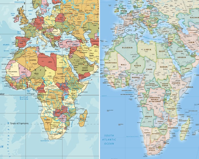
The African Union is supporting a campaign to stop governments and international organizations from using the 16th-century Mercator world map, pushing instead for maps that show Africa’s true size.
Created by cartographer Gerardus Mercator for navigation, this map distorts the sizes of continents—making areas near the poles (like North America and Greenland) appear larger while shrinking Africa and South America.
“It might seem like just a map, but it’s more than that,” said Selma Malika Haddadi, deputy chair of the African Union Commission. She explained that the Mercator map gives a false impression that Africa is small and insignificant, when in fact it’s the world’s second-largest continent by area, home to over a billion people.
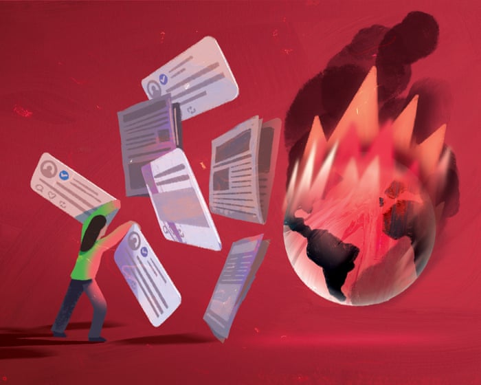
These distortions influence media, education, and policy, she added.
Criticism of the Mercator map isn’t new, but the “Correct the Map” campaign—led by advocacy groups Africa No Filter and Speak Up Africa—has reignited the debate. They’re urging organizations to adopt the 2018 Equal Earth projection, which better represents countries’ actual sizes.
“The current map of Africa is wrong,” said Moky Makura of Africa No Filter. “It’s the world’s longest-running misinformation campaign, and it has to stop.”
Fara Ndiaye of Speak Up Africa said the Mercator map affects Africans’ sense of identity and pride, especially children who see it in school. “We’re working to promote a curriculum where the Equal Earth map becomes the standard in African classrooms,” she said, hoping global institutions will follow.
Haddadi said the AU supports the campaign, aligning with its goal of reclaiming Africa’s rightful place globally, especially amid calls for reparations for colonialism and slavery. The AU will push for wider adoption of accurate maps and discuss collective action with member states.
Despite criticism, the Mercator projection remains widely used in schools and by tech companies. Google Maps switched to a 3D globe view on desktop in 2018 but still defaults to Mercator on mobile.
The “Correct the Map” campaign is urging organizations like the World Bank and UN to adopt Equal Earth. A World Bank spokesperson said they already use Winkel Tripel or Equal Earth for static maps and are phasing out Mercator online.
The UN’s geospatial body, UN-GGIM, will review the campaign’s request once received.
Other regions, like the Caribbean, support the AU’s efforts. Dorbrene O’Marde of the Caricom Reparations Commission called the Equal Earth map a rejection of the Mercator’s “ideology of power and dominance.”
FAQS
### **FAQs About the African Union’s Call to Stop Using the Mercator Map**
#### **Beginner-Level Questions**
**1. What is the Mercator map?**
The Mercator map is a world map projection created in 1569 that distorts the size of landmasses, making regions near the poles appear larger than they are, while shrinking regions near the equator.
**2. Why does the African Union want to stop using the Mercator map?**
The African Union argues that the Mercator map misrepresents Africa’s true size, making it look much smaller than it really is, which can reinforce outdated colonial perspectives.
**3. How does the Mercator map distort Africa’s size?**
On the Mercator map, Africa appears about the same size as Greenland, but in reality, Africa is **14 times larger** than Greenland.
**4. What map alternatives are being suggested?**
Maps like the **Gall-Peters projection** or the **AuthaGraph** show landmasses more accurately in terms of size, though they may look less familiar.
**5. Why does the Mercator map still get used if it’s inaccurate?**
It’s useful for navigation, and many people are used to it from school maps and digital tools like Google Maps.
—
#### **Advanced-Level Questions**
**6. What are the political implications of using the Mercator map?**
Critics say it reinforces a Eurocentric worldview by exaggerating the size of wealthy Northern countries while minimizing the Global South.
**7. How does the Mercator projection affect perceptions of Africa?**
It can make Africa seem less significant geographically, economically, and politically, even though it’s the **second-largest continent**.
**8. Are there any downsides to switching to more accurate maps?**
Some people find alternative projections less familiar or harder to read for navigation, and changing educational materials takes time.
**9. Has any country officially stopped using the Mercator map?**
Some schools and institutions have switched to more accurate maps, but no country has banned it entirely.
**10. How can I see the true size of countries compared to each other?**
Tools like