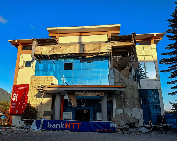
A 7.7-magnitude earthquake in eastern Indonesia has killed at least 40 people, causing widespread panic and destroying buildings and homes in a region that often experiences deadly seismic events.
Authorities issued a tsunami warning, which has since been lifted, but there have been at least 235 aftershocks, including one with a magnitude of 6.1. Indonesian officials said monitoring showed no major sea level changes that could signal a tsunami. Tsunami waves of about 1.5 meters (3 feet) were recorded in some areas.
View image in fullscreen
A motorcyclist rides past a crack in the road in Mbay, Nagekeo, East Nusa Tenggara province. Photograph: Ignasius Kunda/EPA
The Indonesian geophysics agency, BMKG, recorded the first quake at 4:58 a.m. local time on Saturday at a depth of 9 miles (15 km) in the Flores region. A second earthquake, with a magnitude of 6.1, struck off northern Sumatra hours later, with no casualties reported so far.
Rescuers in the port town of Maumere found 20 people dead, six seriously injured, and two trapped under rubble, said Fathur Rahman, head of the city’s rescue agency. Eight of the dead were killed in a landslide. Maumere is the main town in Sikka regency on Flores Island, in the eastern part of Indonesia’s vast archipelago.
A video on Facebook, verified by Reuters as being from a port in Maumere, shows parts of a building collapsing as people scream and run in the street. Another video shows a coastal village covered in mud and debris after a 1.61-meter tsunami wave hit Ngada village in east Manggarai.
View image in fullscreen
Patients are treated in the hallway of a hospital in Labuan Bajo, East Nusa Tenggara province. Photograph: Firdia Lisnawati/AP
“I have never felt an earthquake this big,” said Yulian Juita Ekalia, a university professor who lives more than 60 miles from the epicenter. “It felt like we were on a trampoline, it was really scary.”
The epicenter was located off the north coast of Flores, about 42 miles northwest of the coastal town of Ende, according to US and Indonesian authorities.
Teams have not yet reached Nagekeo, the region closest to the epicenter, and communication signals there have been affected, Fathur said. Landslides blocked road access, and a team was trying to reach the area by ferry, he added.
The police chief of East Nusa Tenggara province, Rudi Darmoko, said the earthquake caused power cuts that made communication between cities and villages difficult, complicating rescue efforts.
View image in fullscreen
People are forced to leave their homes in Talibura village, Sikka, East Nusa Tenggara. Photograph: Arnold Welianto/AFP/Getty
“We are continuing to collect reports of damage and casualties, but there are communication disruptions,” he said. He also noted that landslides in Ende regency had cut off the Trans-Flores highway, a 435-mile mountain road.
Residents in Nagekeo regency rushed to higher ground immediately after the earthquake.
“Suddenly it started to shake and I panicked,” said Lukas Lotar, a hospital customer service official. “Patients also fled the hospital, the jolt was big. I saw some walls were cracked.”
Yohanes Babo, 56, a Nagekeo resident, said he was at a market when the quake hit. “The shaking was strong. Thankfully, we were already outside the house,” he said. “People were panicking, running here and there. We’re evacuating for the time being … and trying to get to the hills. My family is safe. No one was harmed.”
View image in fullscreen
Patients receive treatment inside a makeshift tent outside a hospital in Labuan Bajo, East Nusa Tenggara province. Photograph: Firdia Lisnawati/AP
About 2,000 people in Nagekeo evacuated, and damage to a number of houses, warehouses, and government facilities was reported, according to the national disaster mitigation agency, the BNPB. Authorities also reported traffic congestion and power cuts affecting parts of the regency.
Local television showed patients at several hospitals being evacuated from buildings as a precaution after the quake. Healthcare workers set upTemporary treatment areas were set up outdoors, with beds, IV stands, and oxygen tanks moved onto the streets.
View image in fullscreen
Damaged homes in Ruteng, East Nusa Tenggara. Photograph: Selo/AFP/Getty
The BNPB, which reported the quake’s toll as one dead and four injured, said it was still collecting information.
Television broadcasts in Indonesia showed hundreds of people in the nearby Nagekeo regency evacuating the area, surrounded by rubble from damaged buildings.
Yohanna Embu, a resident of Sikka, a regency in East Nusa Tenggara province, said several buildings had been damaged by the strong shaking, and panicked residents fled to higher ground. “Many buildings here were damaged … I saw that the waiting room at the port terminal in Maumere had collapsed,” she said.
Indonesia, which spans more than 17,000 islands, is prone to earthquakes and volcanic activity because it sits on the “ring of fire,” a zone of intense geophysical activity in the Pacific basin.
In 2004, a 9.1-magnitude earthquake struck off the coast of western Indonesia, triggering a tsunami that killed 220,000 people across the Asia Pacific region.
With Agence France-Presse and Reuters
Frequently Asked Questions
Here is a list of frequently asked questions about the powerful earthquake in eastern Indonesia designed to cover a range of information levels
General Beginner Questions
1 What exactly happened in eastern Indonesia
A very strong earthquake struck the eastern part of Indonesia specifically in the Maluku Islands region The quake was powerful enough to cause significant damage and tragically has resulted in dozens of fatalities
2 How strong was the earthquake
The earthquake had a preliminary magnitude of 75 according to Indonesian meteorological and geophysical agencies It was a shallow earthquake meaning it originated relatively close to the Earths surface which makes it more destructive
3 Where exactly did it hit
The epicenter was located in the Banda Sea near the Tanimbar Islands which are part of Maluku province The main impact was felt on these islands as well as in nearby regions
4 Did it cause a tsunami
Initially a tsunami warning was issued for the area but it was later lifted While there were some small sealevel changes a significant destructive tsunami did not occur The main danger was the shaking itself
5 Why do earthquakes happen in Indonesia
Indonesia sits on the Ring of Fire a horseshoeshaped area around the Pacific Ocean where several tectonic plates meet These plates constantly push against each other and when they suddenly slip or break the energy released causes earthquakes
Impact Details
6 How many people were affected or killed
As of the latest reports dozens of people have been confirmed dead Hundreds more have been injured and thousands have been displaced from their homes The numbers are expected to change as rescue teams reach more remote areas
7 What kind of damage did it cause
The shaking caused widespread damage including collapsed homes damaged government buildings and disrupted roads and bridges Power lines were downed causing widespread blackouts and communication networks were severely disrupted
8 Are there still aftershocks
Yes absolutely It is very common for strong earthquakes to be followed by aftershocks Dozens of smaller tremors have been recorded which can cause further damage to already weakened structures and hamper rescue efforts
9 Why is the death toll so high for an earthquake
Several factors contribute to this