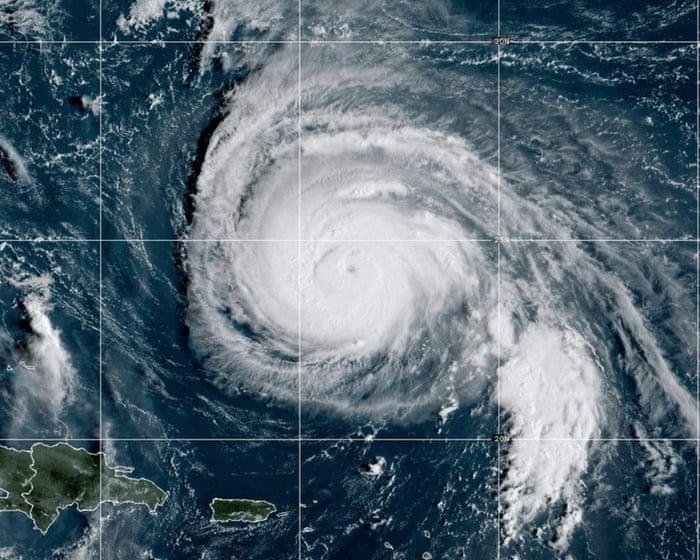
Hurricane Humberto remains a powerful Category 4 storm over the Sargasso Sea north of the Caribbean. On Sunday, it weakened slightly after briefly reaching Category 5 strength the day before with sustained winds of 160 mph.
Although Humberto is expected to stay offshore and pass west of Bermuda from Monday night into Tuesday, its effects will still be felt. Large swells, dangerous rip currents, and rough surf will impact the Lesser Antilles and the U.S. east coast in the coming days. Bermuda is likely to experience sustained winds exceeding 70 mph from late Monday through Tuesday.
Meanwhile, attention is turning to Tropical Storm Imelda, which formed farther west on Sunday. Forecasts indicate Imelda will strengthen into a hurricane by late Monday or early Tuesday after moving through the Bahamas and skirting Florida’s east coast. Models predict a sharp turn in its path, with Imelda likely curving toward Bermuda as a Category 1 hurricane by Thursday night.
Even before intensifying, Imelda brought heavy, dangerous rainfall to the Caribbean. Flooding in the Dominican Republic and Puerto Rico caused two deaths on Friday. By Sunday afternoon, some private weather stations had recorded nearly 90 mm (3.5 inches) of rain in just 12 hours.
In the Dominican Republic, over 400,000 people experienced water supply issues. Mandatory evacuations were ordered for parts of Grand Bahama, and international airports there closed on Sunday.
The National Hurricane Center forecasts rainfall totals of 150–300 mm (6–12 inches) through Tuesday across Cuba and the Bahamas, raising the risk of flash floods, urban flooding, and possible mudslides in higher areas of some Caribbean islands.
Imelda’s moisture is also expected to reach the Carolinas, where rainfall could exceed 170 mm (6.6 inches) by Wednesday, increasing flood concerns along rivers and low-lying regions. A storm surge of up to 2 feet is possible along the Carolina coasts, with surges near 3 feet in the Bahamas.
In a separate weather development, a sharp cold snap is set to sweep across Eastern Europe later this week, bringing temperatures well below seasonal averages. Daytime highs in many areas may only reach the mid-single digits Celsius, more than 10°C below normal for early October. Some locations, including Sarajevo in Bosnia and Herzegovina, could see temperatures up to 15°C lower than usual.
Low pressure will bring widespread rain, turning to snow at higher elevations in the Dinaric Alps. Up to 30 cm of fresh snow is possible between Thursday and Friday.
Frequently Asked Questions
Of course Here is a list of helpful and clear FAQs about Tropical Storm Imelda written in a natural tone
General Information Definitions
Q What is Tropical Storm Imelda
A Its a tropical cyclone with sustained winds between 39 and 73 mph Its currently being monitored as it moves through the Atlantic
Q Whats the difference between a tropical storm and a hurricane
A The main difference is wind speed A tropical storm has winds of 3973 mph while a hurricane has winds of 74 mph or higher
Q What does it mean that Imelda may strengthen into a hurricane
A It means meteorological conditions are favorable for the storm to become more organized and its wind speeds to increase to 74 mph or greater
Q What is the Caribbean in this context
A It refers to the region including the Caribbean Sea and the islands within it such as Puerto Rico the Dominican Republic Cuba Jamaica and the Lesser Antilles
The Current Situation Forecast
Q Where is Tropical Storm Imelda right now and where is it expected to go
A For example According to the latest update from the National Hurricane Center the storm is located a few hundred miles east of the Lesser Antilles and is forecast to move westnorthwest toward the Caribbean islands
Q How likely is it that Imelda will become a hurricane
A Forecasters give a probability often as a percentage or chance You should check the official National Hurricane Center forecasts for the current probability which can change as new data comes in
Q You mentioned a second hurricane What was the first one
A The first one was Hurricane Felix which struck earlier this week
Impacts Dangers
Q What are the main dangers of a hurricane
A The three biggest dangers are 1 Storm surge a rise in sea level that