Justin Goss was in the shower when he first heard the sharp wail of a nearby tsunami warning siren. Still dripping wet, he pulled on clothes, grabbed his dog, and ran to his truck. They only made it three meters before they were stuck.
“The whole parking lot across the street was jammed. It was total gridlock within three minutes,” he says. “I thought, ‘Oh no, this is bad.'”
In downtown Tofino, a town on Vancouver Island, there are no warning sirens. But news spread quickly that people were fleeing the beaches. Anxious parents rushed to pick up their children from day camps. Restaurants in the popular Canadian vacation spot emptied.
“We told everyone to get out fast,” recalls Brenna MacPherson. “We didn’t know how bad it would be.” Some customers paid their bills, while others left without paying. A few wandered the streets with cocktails in hand.
Residents of this small town have long been prepared for a deadly tsunami. When—not if—a tectonic plate thrusts upward, the released energy will create a wave moving as fast as a jet. As it approaches shallow water, it will slow to about 20 miles per hour (32 km/h)—slower than an elite sprinter—but grow in size. A wall of water up to 20 meters (65 feet) high could hit the shore.
This summer, on July 29, a powerful but distant earthquake in Russia’s Kamchatka region set off sirens in Tofino. Hours later, when the wave arrived, it was little more than a swell against the coast. Still, the false alarm made residents face the town’s risky location and an old question: how do you prepare for a disaster whose timing is completely unknown?
Tofino is a narrow strip of dense forest bordered by miles of beach that bear the full force of the Pacific’s unpredictable weather. It is connected to the rest of Vancouver Island—and to food, medicine, and fuel—by a single highway full of steep slopes, sharp turns, and rockslides.
About 60 miles (100 km) offshore, the Juan de Fuca plate slides under the North American plate—a slow collision where pressure builds over centuries. When it finally gives way, it triggers a “megathrust” earthquake. Similar events have happened 19 times in the past 10,000 years—the last in 1700, when 600 miles of seafloor dropped 20 meters and a massive wave spread in all directions.
The disaster is recorded in the oral histories of Indigenous peoples on Vancouver Island. Villages and forests disappeared, and ocean rocks ended up in lakes. One Nuu-chah-nulth story, hundreds of years old, tells of an orca named K’aka’win that was carried more than a mile from an inlet to Sproat Lake by a tsunami. The killer whale survived for almost a month before dying in the freshwater.
Fears that the Kamchatka earthquake might cause tsunamis worldwide this summer did not come true.
Katsu Goda, a professor at Western University in Ontario who studies catastrophe modeling, recently visited Tofino to meet with colleagues from Indonesia and Cuba. They are part of a project to develop response plans with local officials.
On the morning of October 3, nearly 40 people crowded into a hotel conference room. Around the tables were flood experts, sociologists, hotel managers, town councillors, firefighters, and disaster-response staff. Their task was “community asset mapping”—an exercise to identify the town’s weaknesses that could slow down disaster response.The Guardian
The room fell into hushed astonishment when the soft-spoken Goda informed attendees that an earthquake measuring 9 on the Richter scale is nearly 1,000 times more powerful than one measuring 7. Yet when a quake of such destructive force hits, officials and first responders must disregard its immediate effects because of the tsunami that follows minutes later—a wave whose strength depends on tides, storms, and whether the earthquake lifts or lowers the land.
Tofino faces another challenge: seasonal crowds. Its bohemian charm and impressive waves have long attracted surfers, and hundreds of thousands of visitors gather in its low-lying areas during holidays. In most earthquake scenarios, when the “big one” strikes, anyone near the beach has roughly 15 minutes to reach higher ground. But Goda warns that those minutes can be deceptive.
“You might lose five minutes waiting for aftershocks. If it’s daytime, the journey is much easier than at night. And just when you’re ready to leave, you might realize you need to find your children.”
Road signs direct people to higher ground in case of a tsunami. Photograph: Leyland Cecco/The Guardian
The town is vulnerable in other ways too. Tofino’s drinking water comes entirely from a nearby island. Climate change is eroding beaches and intensifying storms that push water further inland. “Atmospheric rivers”—long, narrow bands in the sky that carry moisture from the tropics—as well as rockslides can block the only highway. Last summer, wildfires came dangerously close to the road.
Although artificial intelligence has influenced nearly every field, Goda notes that it remains an expensive and impractical tool for creating accurate tsunami models.
“To build a credible model, we need experience. But we lack fundamental information because there’s so little reliable data on tsunamis,” he explains.
The only useful data available come from the 2011 Tōhoku earthquake in Japan and the 2010 quake in Chile, but neither can accurately predict what might happen in Tofino.
The town plans to construct a tsunami-proof evacuation tower capable of sheltering thousands of people. Photograph: Leyland Cecco/The Guardian
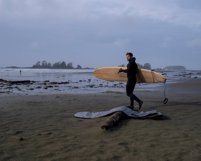
At Chesterman Beach, one of Tofino’s most popular spots, waves crash along the shore as enthusiastic surfers ride the foamy swells. A recent storm has left bull kelp, shells, and fresh driftwood scattered across the sand. Bundled-up tourists take in the rugged coastal scenery.
Many visitors are aware of the tsunami risk but mistakenly believe they would have about an hour to reach safety. For Hilary O’Reilly, this misconception is a serious concern.
As Tofino’s emergency program coordinator, O’Reilly faces the challenge of educating a community whose population swells and shrinks with tourism. She must ensure that weekend visitors know the evacuation routes and strike a careful balance between raising awareness and causing alarm among residents and their families.
“My job is to help people manage their fear as much as possible,” O’Reilly says.
Most residents have enrolled in a mobile phone alert service.Signs along the highway guide travelers to higher ground, and the main beaches are equipped with sirens. Plans are in place to install more in town and nearby First Nations communities.
Tofino aims to construct a vertical evacuation tower—a wave-resistant structure that could shelter thousands of people seeking safety from tsunamis. Such towers have proven life-saving in Japan, and Canada’s first is currently being built in Haida Gwaii, an archipelago just north of Vancouver Island. However, the most suitable locations for these towers are also the most geologically unstable, susceptible to liquefaction, where sandy soil behaves like liquid during an earthquake.
Hilary O’Reilly, Tofino’s emergency program coordinator, leads “high ground hikes” for residents to familiarize them with safe routes.
Beyond these efforts, O’Reilly faces the broader challenge of preparing for the unpredictable. Highways are likely to be damaged or destroyed in a major earthquake. How many fallen trees will block the roads, and how will that affect panicked crowds trying to escape?
Before becoming a popular eco-tourism destination for affluent visitors, Tofino was a rugged outpost for fishing and logging, earning the nickname “Tuff City.” Locals describe a culture of resilience and adaptability, shaped by the harsh environment. Power outages and spotty cell service are common here. The town’s disaster plans acknowledge that overcoming a catastrophe will depend on trust in human nature.
“What will get us through a large disaster is a sense of community,” says O’Reilly. “People coming together when they’re needed is a beautiful part of humanity that emerges in difficult times. And we know this town will come together—because it has to.”
Though the threat of a disaster feels distant, it holds an abstract presence in the town’s consciousness. O’Reilly’s high-ground hikes help families learn the local landscape. Near where Goss lives, tourists photograph signs warning of the tsunami flood zone. Souvenir shops sell T-shirts with a playful twist: a surfer racing toward a massive wave.
“We know the risk is there, but people don’t talk about it much,” says Goss. “We’re not living in fear of a tsunami every day. But maybe we should think about it more than we used to.”
A surfer enjoys the waves on Chesterman Beach after a storm.
Frequently Asked Questions
Of course Here is a list of FAQs about a Canadian town preparing for a tsunami disaster written in a clear and natural tone
General Beginner Questions
1 Wait Canada gets tsunamis I thought that was a Pacific Ocean thing
Yes absolutely Canadas west coast particularly British Columbia is in an active earthquake zone called the Cascadia Subduction Zone which can generate massive tsunamis
2 Which Canadian town is this about
While several coastal communities in BC are at risk the town of Tofino on Vancouver Island is often highlighted in these discussions due to its popularity with surfers and its lowlying location
3 What exactly is a tsunami
A tsunami is a series of enormous ocean waves caused by largescale disturbances like undersea earthquakes volcanic eruptions or landslides
4 Why are surfers and a tsunami threat in the same place
The same geological forces that create the risk of a major earthquake also create the deep underwater canyons and seafloor shapes that produce consistent large wavesmaking it a worldclass surfing destination
5 What are the main signs that a tsunami is coming
The main natural warning signs are a strong longlasting earthquake that makes it hard to stand up a sudden and unusual rise or fall in the ocean level or a loud roaring sound from the ocean
Preparedness Safety Questions
6 How is the town preparing for a potential tsunami
The town is preparing with robust early warning systems clearly marked evacuation routes and signs regular community drills and education programs and the construction of designated vertical evacuation structures in areas where you cant reach high ground in time
7 What should I do if Im visiting and feel an earthquake
If you are on the coast and feel a strong earthquake that lasts more than 20 seconds dont wait for an official warning Drop Cover and Hold On during the shaking and as soon as it is safe move immediately to high ground or inland Do not go to the beach to watch the waves
8 Where are the tsunami evacuation routes
Tsunami evacuation routes are clearly marked with blue and white signs showing a wave and an arrow pointing uphill You will see these signs throughout atrisk coastal communities Its a good idea